
Chase Recap: The 3/21/22 Jacksboro, TX EF-3

I was becoming increasingly mad at myself as I pulled into the Walmart parking lot in Wichita Falls, TX.
After several hours on the road - much of it through heavy rain - I needed a break and wanted to take a closer look at the latest radar and satellite imagery as well as surface observation. This was really just an attempt to convince myself that I hadn’t just wasted an entire day driving to north Texas. Monday, March 21, 2022 was a rare weekday off work with no other pressing obligations that left me free to chase. A day shift the following morning meant that driving down I-35 to the Moderate risk area closer to Austin, TX was out of the question, my best option was to target north Texas, but there were some legitimate concerns that the chase could bust, and I had plenty of household chores that needed attention. It was the common conundrum: chase and risk a bust or actually accomplish something useful at home?
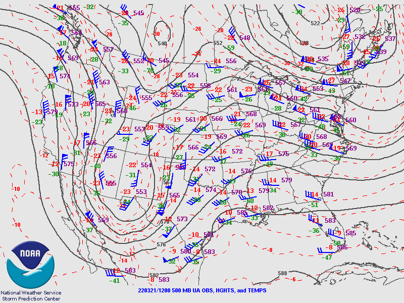
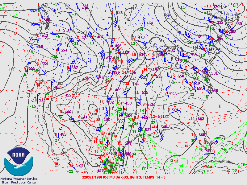
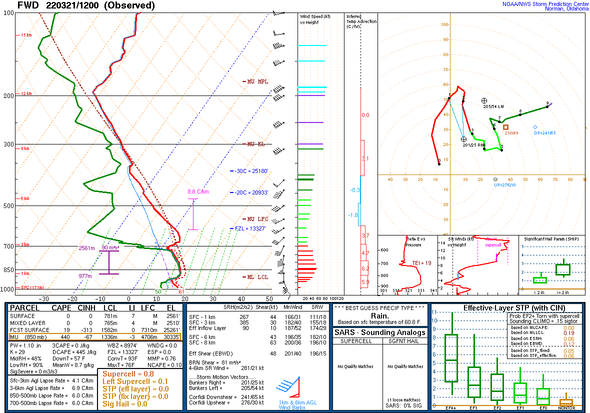
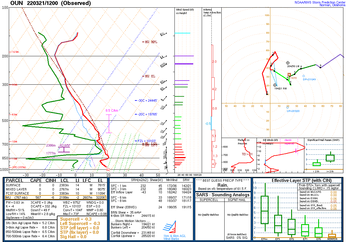
To paint a picture of my concerns, we’ll start with the upper air regime. The 12 UTC ROABs sampled a highly amplified 500 mb low centered over southern AZ/NM with a meridional 50-70 knot jet streak emanating out of northern Mexico extending into the southern High Plains. A second jet streak was also present diving southeast across the Gulf of California. From a QG standpoint, this suggested that the trough would likely meander east through the day with strong upper-level winds and modest large-scale ascent across much of TX and OK. At 850 mb, an impressive low-level jet was sampled at FWD and OUN with 55 knot southerly flow pumping moisture and warm air northward. This meant two things: 1) surface pressure falls would likely be greatest across north TX under the strongest warm air advection, 2) a lot of isentropic-driven precipitation. Morning surface observations showed that the surface low was still back west across eastern NM, and surface dewpoints across north TX into southern OK were in the mid 40s to mid 50s - not exactly big-time tornado moisture. The closest 60+F dewpoint was well south of the I-20 corridor, and with sufficiently strong southerly winds, it was feasible for the better moisture to reach the Red River. However, that would be dependent on the track and evolution of the surface low.
A well-defined EML was apparent across southern TX in the 12 UTC soundings with mid-level lapse rates between 7.5 to 8 C/km. Low-level moisture was also very deep: the CRP sounding featured saturated conditions from the surface to 800 mb with a mean mixing ratio of 14.7 g/kg. The same could not be said for the OUN or FWD soundings. While present, the EML was diluted with lapse rates closer to 6.0 to 7.0 C/km. Consistent with surface observations, the mean mixing ratio at FWD was only 8.7 g/kg. Thermodynamically, southern to central Texas was the clear winner. Winds were forecast to increase across southern/central Texas by late afternoon as the mid-level jet streak approached the region, and with the deepening surface low, wind shear would improve and support the potential for “a couple of long-track supercells” per the SPC 1630 outlook. But kinematically, the Red River had one advantage: the warm advection regime also meant strong low-level hodograph curvature. This could support a tornado threat if two conditions were met:
Of the two, condition #1 was a big IF. The potential for heavy rain could halt the northward progression of the warm front, keeping the warmer/more moist air south of north TX. It could also limit the spatial window for storms to mature in. It was possible that storms initiating near the surface low, along the warm front, or along the developing surface trough/dryline could be shoved into the cool stable air before they got a chance to mature.
That said, I’ve seen this pattern work out before. The colder temperatures aloft closer to the upper low combined with stronger synoptic-scale ascent could provide adequate cooling to offset the sub-optimal low-level thermodynamic conditions. The enhanced low-level helicity within the frontal zone could also offset meager buoyancy if a deep enough updraft can become established.My impression by mid-morning was that there wasn’t a ton of rain, so maybe the warm/moist air could reach north TX after all? Ultimately, this line of thinking won out so I grabbed my camera and my lunch and headed out the door.
The rain started about an hour into my drive south.
At first it was just light, intermittent rain, but steadily increased in duration and intensity with southward extent. The pangs of regret increased with every mile I drove south since I knew this meant the chances of getting enough destabilization in my target area were dwindling. But the optimist in me told me to keep going - I had already sunk half the day into this adventure, might as well see it out. My optimism was waning as I pulled into the Walmart parking lot, but I was pleasantly surprised to see broken clouds to my south along the I-20 corridor. Not only were there broken clouds, early convective towers were identifiable in visible imagery. A quick look at mesoanalysis showed increasing SBCAPE to the south along the warm front. The stratiform rain had halted the northward progression of the warm front, but a viable warm sector was developing just to the south - albeit a little more south than I had originally hoped.
Buoyed by these trends, I hopped back on the road and took highway 79 south out of town. Upon reaching Archer City I checked satellite and radar trends again. A combination of discrete and semi discrete cells were beginning to develop along the surface trough, but none looked particularly intense. With no specific target in mind I decided to keep going south to Olney where I had additional east-west highway options. The view to the south wasn't great in Olney, so I jogged east on highway 114 and found a pull off a couple of miles outside of town. Radar continued to show somewhat anemic storms with no clear structure. IR cloud top temps revealed similar trends. It wasnt clear at the time what the next best course of action was. Dive south further into the warm sector or stay on highway 114 and let the storms approach me from the south? Not wanting to wander too far from my north-south option I decided to stay put until the answer became more clear. In the meantime, I snapped a few pictures of the rolling landscape and nearby wind mills while having a snack and taking quick glances at the radar. Might as well do something while I'm doing nothing!
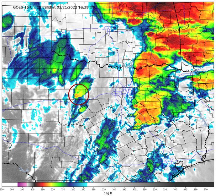
After about 15-20 minutes I did a more comprehensive assessment, and one trend caught my eye. A cell to my south, southeast had shown signs of steady cloud top cooling and was now much colder than neighboring storms. One key lesson I learned after a failed chase in 2017 was to pay attention to IR trends to help identify which storm to target. No storm looked particularly interesting in radar, but this IR trend was likely an early sign of intensification that had not yet manifested in radar imagery. There was nothing else to lose, so I decided to track the cell.
...An ominous gray haze...
The storm motion was north, northeast, meaning it would cross highway 114 somewhere to my southeast. At this point the plan was easy enough: head east on 114, get on the eastern side of the storm, and wait. Heading east/southeast, I could see weaker convection developing to my south, obscuring my view of my target storm. Even if it was clear, approaching the storm from the northwest meant that my view of the updraft would be hindered by precipitation in the forward flank. But radar trends were promising; maximum dBz continued to increase and the early signs of a mesocyclone began to emerge. Shortly after, a tornado thunderstorm warning was issued, and unbeknownst to me, an EF-1 tornado developed over Possum Kingdom Lake. This tornado moved mainly over water, but snapped trees and caused some structural damage as it skipped along the lake shores before dissipating on the north end of the lake.
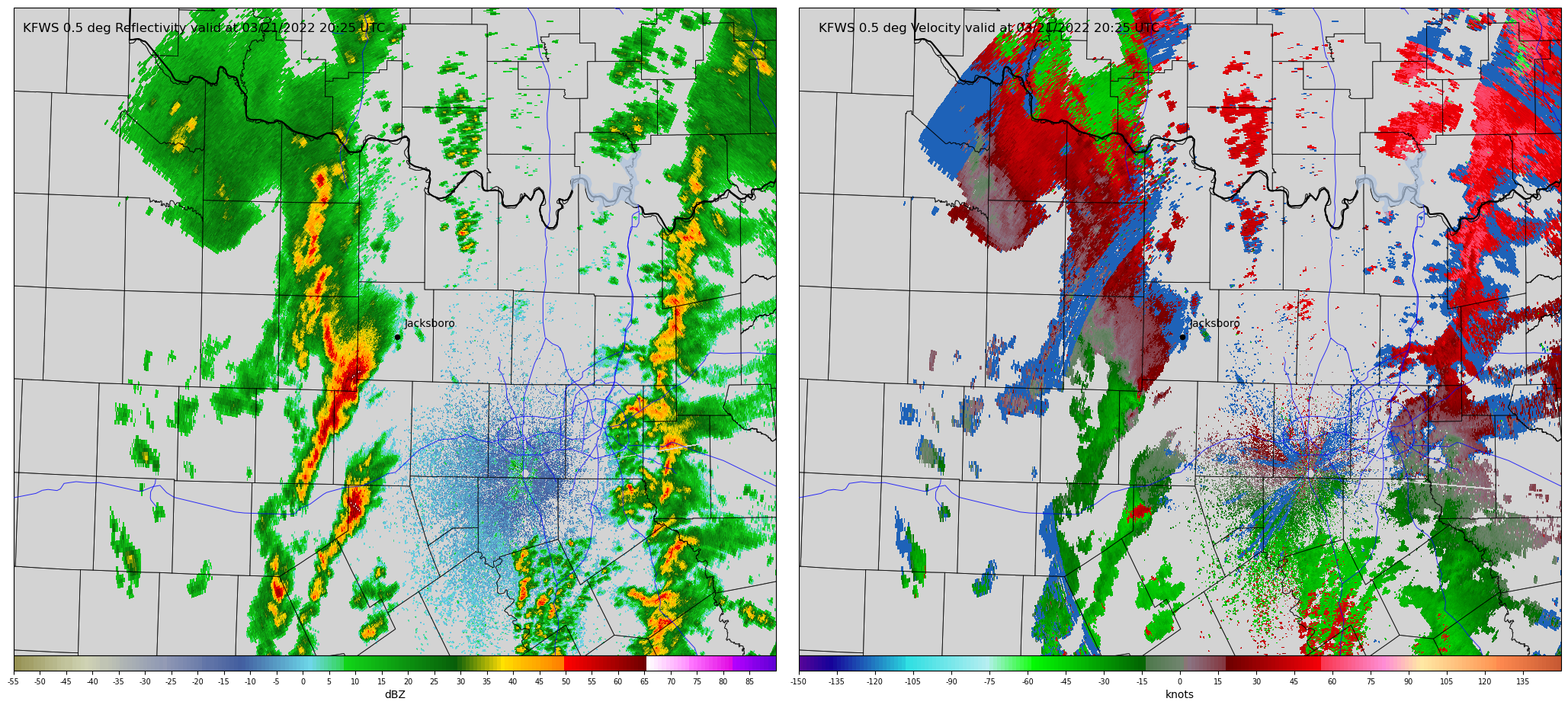
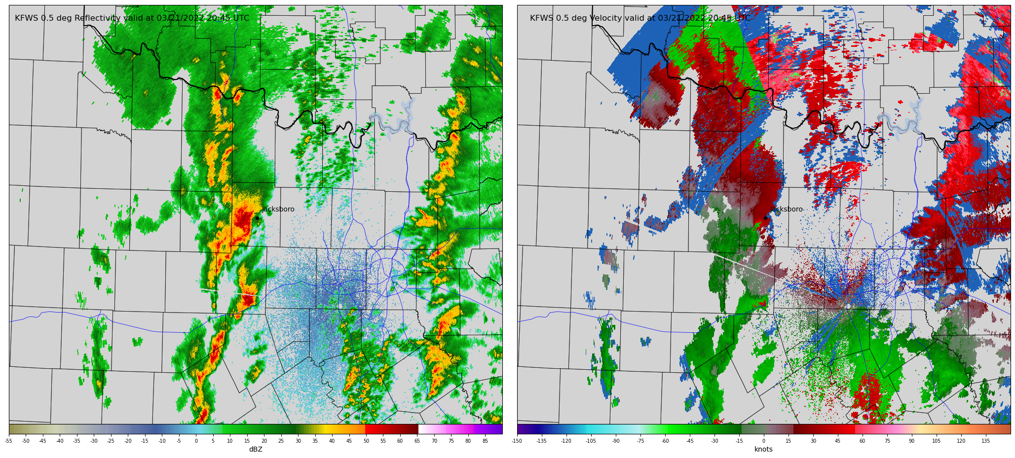
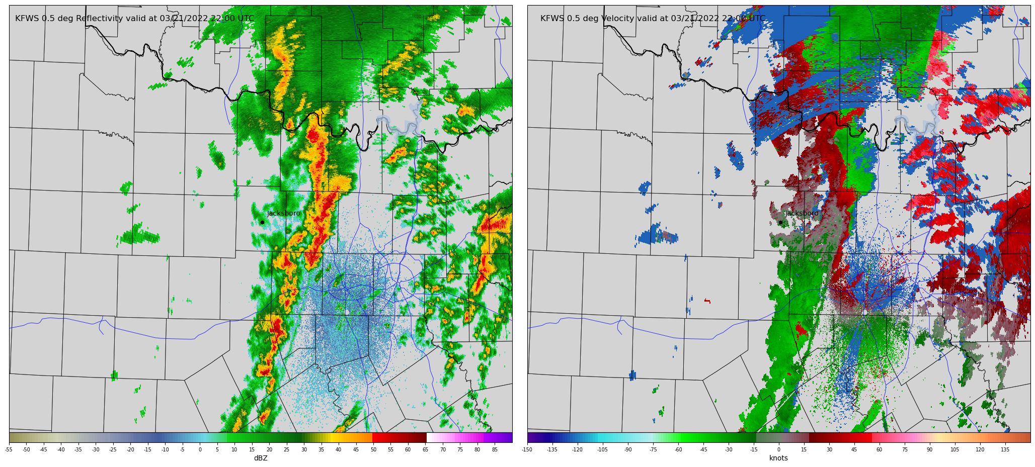
Following highway 114 took me into the west side of Jacksboro. At this point, the storm was almost due south, but I still couldn't see the updraft region due to rain (and now buildings). Although there were five highways expanding out of Jacksboro, none of them continued my desired track of due east. The best I could do was dive southeast on highway 281 and follow highway 380 east. But first I had to get there! A combination of traffic and red lights slowed me to a crawl through town. After an excruciating slog through downtown, I made it to the south side of town on highway 281. I was pleasantly surprised to find that the south side of Jacksboro was atop a hill with a great view southward. This gave me my first good look at the storm. Pulling over, I could see the forward flank to my southwest, but only an ominous gray haze directly south where the wall cloud should have been - it was completely rain wrapped. I didn’t realize it at the time, but the Jacksboro tornado was already on the ground producing EF-2 damage behind the curtains of rain. Watching the radar loop a few times confirmed what I already suspected: the mesocyclone (tornado) was heading for my position. A decision had to be made quickly. I had an east option a few miles to my south, but that required closing distance with a strengthening mesocyclone (tornado) with no realistic escape routes until highway 380. The second option was to go back into town and try to take highway 59 northeast out of town. This was sub-optimal due to a high likelihood of traffic and no great opportunities to increase my eastward separation away from the storm.
I decided to go south. Taking one last look at radar the rotation had increased further, meaning it was now or never. I had to reach highway 380 before the storm reached me. I pulled back onto the highway and accelerated south down the hill. Megadeth's Hangar 18 blasted over my radio as I pushed down harder on the gas. I got one last good look at the gray rain curtains and rising scud on the edge of the curling RFD before they all disappeared behind the trees at the bottom of the hill. After a few minutes of sprinting south it became clear the storm would pass just to my west, though still closer than I'd like while chasing alone. The highway 380 intersection gave me my first real spot to pull over and watch. I hopped out of the car and looked west/northwest just in time to see the scud and rain curtains on the eastern side of the circulation begin accelerating rapidly. This was my first visual indication that something serious was lurking in the rain and I began to suspect a tornado was on the ground. In reality, the tornado had been on the ground for approximately 15 minutes and was destroying a mobile home roughly three miles to my west.
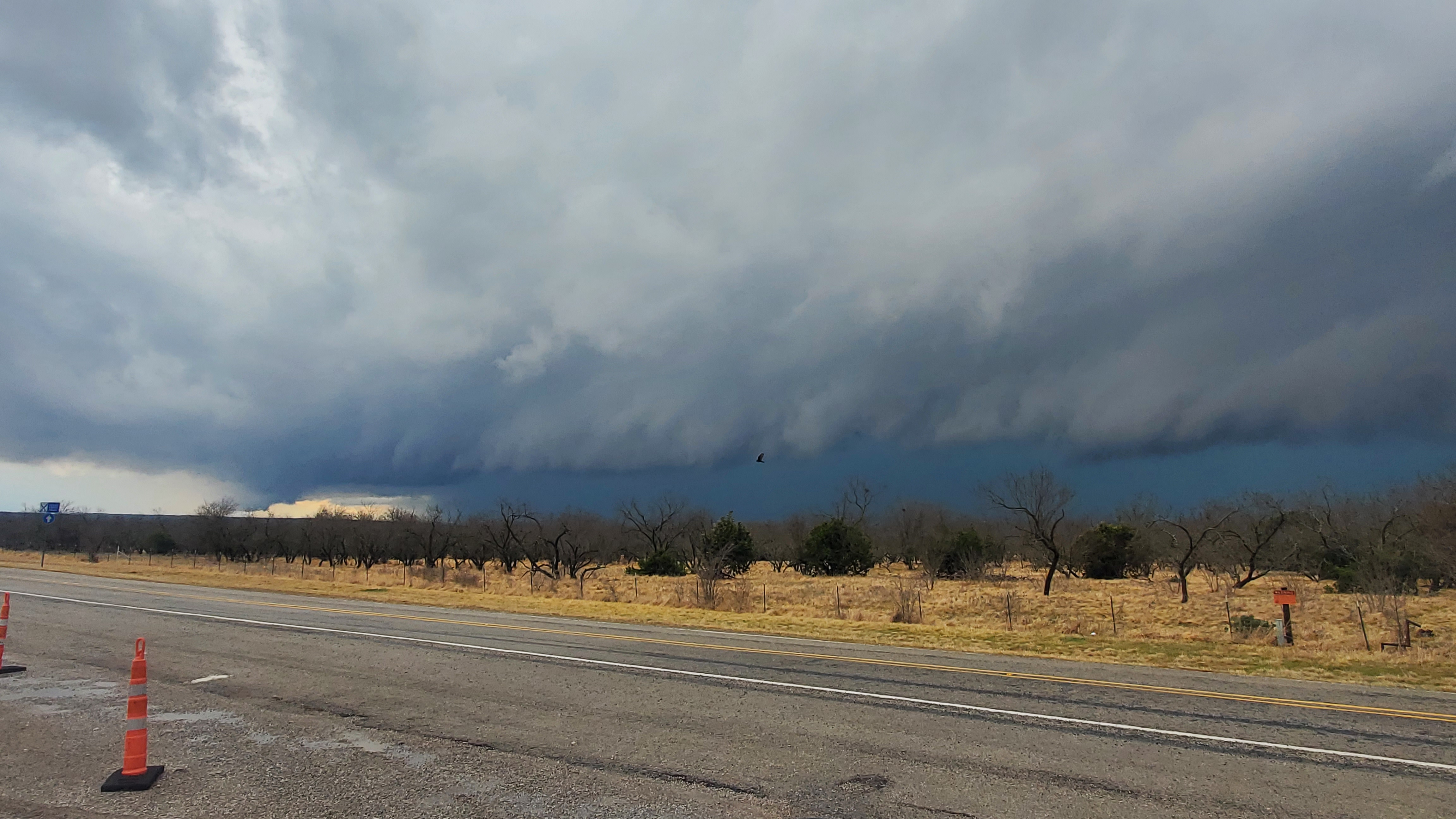
Not wanting to waste time getting my camera put, I snapped a quick picture with my phone as the storm enveloped Jacksboro. The tornado raked across the west side of town, producing EF-3 damage to multiple structures, including an elementary school. Not wanting to go back through town and hoping to get a view of the tornado, I drove east on 380 for a couple of miles before pulling over again. The rain wrapped tornado remained nothing more than a dark haze to my north, and I knew my chase on this cell was done as it raced away to the northeast. The tornado continued on for another 25 minutes as it moved across rural parts of Jack county and into far southwest Montague county, luckily causing little additional damage.

Around this time multiple emergency response vehicles passed me heading west towards 281 and presumably the Jacksboro area. I knew Jacksboro was likely hit, but had no idea how extensive the damage was. A couple of quick texts to friends back home confirmed that there was severe damage. By my estimate, I had left town maybe 5-10 minutes before it was hit. Part of me felt guilty and wondered if I should have gone back to help, but having no medical supplies or experience, chances are I would have just been in the way.
Calling it a day
New cells were developing to my southeast, so I continued east on 380. Thirty minutes later I found myself on the northern side of the forward flank of a developing supercell, once again unable to see the updraft base through the rain. As I reached Lake Bridgeport an WEA alert blared on my phone: a new tornado warning had been issued for my storm, but I was on the wrong side! The road options were poor, leaving me few real options besides continuing on 380 and hoping to break out of the forward flank just ahead of the mesocyclone. Unfortunately, traffic in Decatur slowed me once again. Penny to quarter size hail started falling, prompting inexperienced drivers to slow further. This was infuriating! I watched as the circulation - actually a weak EF-0 tornado - passed to my south on radar, pulling ahead of me to my east, leaving me behind.
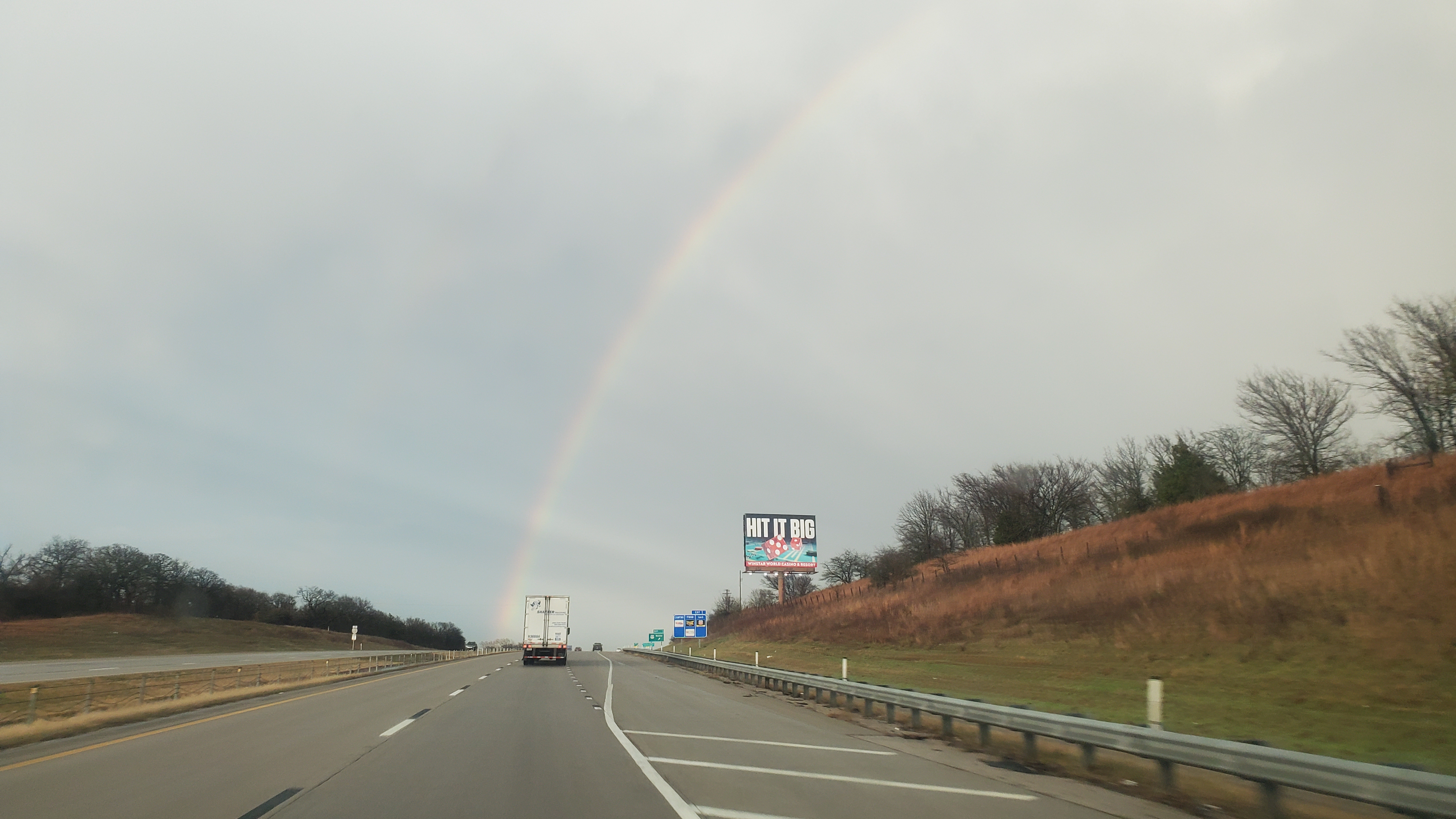
Stuck in traffic and pelted by hail, I decided to pull over and reassess. Convective trends were not in my favor. Initially somewhat discrete cells were beginning to conglomerate into a line with embedded supercells, which was all quickly shifting east, out of reach, and into south-central OK where roads and radar coverage were not conducive for fun chasing. I decided to call it. I followed 380 to I-35 and turned north back to OK. Passing through Gainesville, TX, I noted torn trees, bent road signs, and destroyed fencing where an EF-1 hit the northwest side of town and crossed I-35 around the same time I had pulled over in Decatur. Although additional tornadoes were occurring well to my east, I could only see the backside of the convective towers. I was, however, given a beautiful rainbow as a consolation prize as I crossed into OK.
At the end of the day, my chase on March 21 wasn't very glamorous. I didn't get any breathtaking photos or even see a clear tornado, which stands in stark contrast to the numerous photogenic tornadoes that happened further south near Round Rock, TX. Heck, I barely got to experience severe hail! But I was still proud of this chase. I pushed on in Wichita Falls when I was plagued by doubt, applied hard-learned lessons from previous failed chases, and made sound tactical decisions while maintaining safety. Some days, that’s all you can ask for.
Further information on this tornado can be found here, with additional information about the March 21, 2022 outbreak found here and here.
hidden text