Lessons from J.P. Finley Part 1:
A Tornado Outbreak Methodology
The man, the myth, the legend...
John Park Finley is a name that is not often brought up these days in the weather community - but it should be! Finley is considered to be one of the first tornado forecasters in the U.S. Born in 1854 in Michigan, Finley worked as a meteorological officer in the Army’s Signal Service beginning in 1877, and began focusing on tornado research in the early 1880s. Through his studies, Finley yielded a plethora of insights into tornado forecasting that were decades ahead of their time. (One such example: Finley suggested the creation of a forecasting unit in Kansas City, MO focused solely on tornado forecasting - a premonition of SELS/SPC that was created in the mid 1950s.). (As an aside, those interested in the life of John Park Finley should read Galway 1984.)

While his meteorological career spanned 15 years, it was Finley’s development of a rudimentary methodology for tornado forecasting in 1884 that is most remarkable. Part 1 of this post will focus on Finley’s methodology, and ask whether it still holds value in today’s world of high-resolution observations and numerical weather prediction. Part 2 will take a closer look at Finley’s verification statistics and highlight a lesson that arguably is more relevant now with the emergence of artificial intelligence and machine learning techniques for severe weather forecasting.
Finley's method
Beginning on March 10, 1884 through the end of June 1884 Finley recorded twice-daily tornado forecasts for 18 “districts” across the country (see image below) using nothing more than surface observations taken at 7am and 3pm. His forecasts were rather simplistic by today’s standards - he merely stated whether conditions were favorable or unfavorable for tornado development, but based on his own calculations his experimental forecasts were a resounding success with an accuracy of 96.6% (though we’ll examine this more closely in part 2). But what was his method for determining if conditions were “favorable” or “unfavorable”?

The methodology centers around a set of 10 rules. These rules can be found in his 1886 paper, but were more concisely stated by this NOAA article and restated/paraphrased here for clarity:
Once these ten “rules” were observed in surface maps, then conditions would be considered “favorable” for tornadoes in the areas to the southeast of the surface low. However, there are other secondary factors that were considered:
Meteorology-savvy readers may have already realized that Finley is describing an intensifying surface cyclone not unlike the typical Norwegian Cyclone Model. Keep in mind, however, that the Norwegian Cyclone Model didn’t emerge until the 1910s and 1920s - roughly 30 years after Finley’s rules. But the question is can we use these rules to help forecast tornadoes today? The answer is both yes and no.

Yes, you can!
If you read between the lines of Finley’s rules there are several key features that stand out and are regarded as crucial for modern tornado forecasting. For starters, let’s look at rules 1 and 6. The presence of a surface low and increasing wind velocities around the surface low imply strong synoptic ascent. Such ascent is typically associated with a strong upper-level feature such as an upper trough and/or upper jet. From an ingredients-based framework, strong synoptic ascent is important for destabilizing mid-level lapse rates (i.e. increasing CAPE), and the presence of some upper-level feature typically implies some degree of deep-layer wind shear. Additionally, increasing low-level winds near the surface low help augment low-level wind shear. Rule 4 also implies that a strong upper-level feature must be in place since surface highs typically follow in the wake of upper-level troughs.
Rules 2 and 10 both point towards the importance of increasing low-level theta-e within the warm sector of a cyclone. Meteorologists today closely monitor the progression of low-level moisture ahead of a severe weather outbreak since moisture, like lapse-rates, has significant implications for buoyancy and overall convective intensity.
Rules 5 and 9 both point towards the role of mesoscale forcing for ascent. Keep in mind that the idea of cold fronts, warm fronts, or drylines wasn’t commonplace in 1884, but Finley noted that strong baroclinic zones were necessary for thunderstorm development. Combined with rules 7 and 8, Finely begins to describe the orientation of the fronts relative to the surface low during the cyclone’s intensifying and mature stages. Some sources mention the importance of dewpoint gradients as well, but one could interpret rules 7 and 8 as describing a Pacific front and an Arctic front respectively.
Finley’s use of other factors, such as time of year and the movement of clouds, also point towards tools that we use today: tornado climatology and deep-layer wind shear. The expectation of tornadoes to the southeast of the surface low also checks out: this would be right across the open warm sector ahead of the advancing Pacific front. So while somewhat basic, Finley’s rules come remarkably close to outlining many of the key features we look for in modern severe thunderstorm forecasting.
In fact, these rules can still be applied today under certain circumstances: namely when there is an expectation of a strong, intensifying cyclone driven by robust, synoptic-scale upper-level features. One recent example of this is the tornado outbreak of March 31, 2023, which saw over 160 tornadoes tear across the Midwest and parts of the lower-MS and TN River Valleys. Take a close look at the surface analyses from 15 UTC and 21 UTC on March 31 and note how many of Finley’s rules are satisfied.

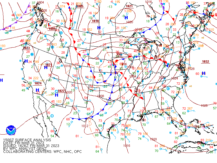

At 15 UTC we see a pronounced surface low over eastern NE/western IA that is roughly oriented southwest to northeast (rules 1 and 3 - ✅). The temperature delta between the warm sector in AR and the post-frontal regime in SD/NE is ~ 40 F (rule 9 - ✅). Along the Pacific front and the warm front, the temperature gradients were around 10-20 F by 21 UTC (rule 5 - ✅). Comparing wind velocities between 15 and 21 UTC, we see a marked increase in wind speeds in proximity to the surface low (rule 6 - ✅). Is there a northward surge of moisture during the 6-hour span? Yep! Rule 2 - ✅. The orientations of the Pacific front draped to the south of the low and the arctic cold front to the west/southwest of the low also appear to satisfy rules 7 and 8. The only rule that does not appear to be satisfied is rule 4 - the southward migration of a surface high (a surface high is present in southern Canada, but remains nearly stationary). Regardless, 9 of the 10 rules are satisfied, and where did the bulk of the tornadoes occur? In the southeast quadrant as predicted by Finley’s method!
I will admit that this final point should come with an asterisk attached. The highest concentration of tornadoes was focused along the synoptic warm front where modern meteorologists will recognize that low-level SRH is inherently much higher than in the open warm sector. It could be argued that the bulk of the tornado distribution occurred due east of the low rather than southeast. Additionally, Finley’s method is conveniently vague on exactly how far to the southeast one can expect tornadoes to occur, should the plethora of tornadoes from AR to TN and northwest GA count? While these finer points can be debated, the bigger picture is that even today’s Finley’s methodology can be useful as a sanity check or a confidence builder for forecasting synoptically-driven tornado events.
No, you can't!
Although Finley’s method worked great for the outbreak of March 31, 2023, synoptic regimes similar to March 31 are fairly rare and infrequent, and most tornadoes occur on days with far fewer total tornado counts (i.e. on lower-end outbreak days or on non-outbreak days). While many of these lower-end or non-outbreak days likely have synoptic-scale features that are contributing to the severe weather threat, many of them may satisfy fewer of Finley’s rules and lead to a “unfavorable tornado conditions” forecast.
Let’s check out an example to illustrate this point. May 25, 2024 saw 48 tornadoes across the southern Plains into northwest AR and southwest MO, including killer tornadoes in TX and AR. This is hardly an event you’d want to miss from a forecast perspective! Unlike, the March 31 event, May 25 was a classic southern Plains dryline set up with a lee cyclone deepening across eastern CO. We’ll look at surface analyses from 15 UTC and 21 UTC to see which of Finley’s rules are satisfied.


Rule 1: A pronounced and anomalously strong surface low? Maybe by 21… half-check.
Rule 2: A northward flux of heat/moisture? Check!
Rule 3: A north-south or southwest-northeast orientation of the low/trough? ✅
Rule 4: A descending surface high? ❌
Rule 5: Strong temperature gradients? Maybe 10-15 F across the dryline… half-check.
Rule 6: Increasing wind speeds in the vicinity of the low? Only at ABQ, otherwise ❌.
Rule 7: A northward curve of the warm sector isotherms? ❌ The warmer temperatures behind the dryline
result in more zonally-oriented isotherms.
Rule 8: A southward curve of the cold sector isotherms? ❌ While a cold front is technically
analyzed at 21 UTC, there really isn’t much of a substantial cold front to speak of.
Rule 9: Strong temperature gradients between the noses of opposing temperature curves? Maybe…
20-30 F depending on which stations you look at and whether you consider the post-dryline regime to
be the reference point rather than the open warm sector. Half-check.
Rule 10: Increasing humidity to the southeast of the low? ✅.
Tallying up how many rules are satisfied comes down to how strict you want to be. A liberal estimate would say 6, while a more strict interpretation would say only 3. It isn’t clear how many of Finley's rules need to be satisfied to elicit a “conditions favorable for tornadoes” forecast, but this particular regime would be a questionable candidate if one takes a reasonable interpretation of the rules. This highlights the inherent weakness of Finley’s methodology: it is better suited for large-scale, synoptically-evident tornado outbreaks rather than more regional, mesoscale-driven tornado events.
So does Finley’s approach still have a place in today’s forecasting paradigm? I would say yes, but only in certain circumstances. If the expectation going into a forecast is for the development of a large-scale surface cyclone, then Finley’s rules can serve as a helpful confidence booster in the potential for a tornado event. They should not, however, be the primary cornerstone of a forecast, nor should they be used in more mesoscale or storm-scale driven scenarios, such as dry-line set ups, cold-core events, outflow boundary convection, or QLCS tornado events. At this point, the pro-Finley fanatics must be shouting “But wait! Finley had an accuracy rating of 96%!” While true, we’ll dive into why this statistic is misleading and what it means for modern-day AI/ML forecasting tools in part 2.
hidden text!